


Type
Small electric < 7kg MTOW Fixed Wing (FW) Remotely Piloted Aircraft System (RPAS) for Medium-Area (~300 hectares a mission to cm resolution), short-range (1-7km) survey and mapping solution.
Development
The GosHawk™ platform has been developed by V-TOL Aerospace to provide a low-cost, easy to use and reliable extended line-of-sight (LOS) ready mini-RPAS capable of conducting surveying and mapping (color or multispectral) via a belly mounted hi-res camera. The images can be processed post-flight to produce cm accurate color/multispectral mosaics. When used in conjunction with other tiers of mini-RPAS, such as the Swift or Hornet multi-rotor systems, the GosHawk™ can provide broad area coverage while the VTOL system can be deployed to identify a specific target of interest to mm resolution (see Hornet brochure for more information).
Description
Airframe
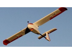
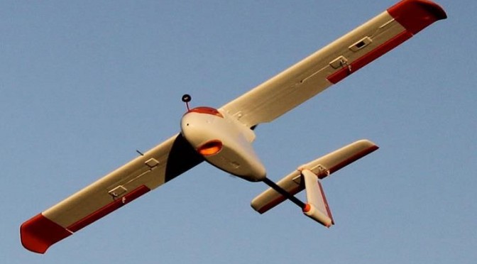
Developed using collision safe materials this hi-wing 3 axis aircraft provides a stable camera platform for airborne imaging operations < 400ft AGL. Thrust is provided by a rear mounted electric power plant. Cameras are located in the nose and belly. Airframe is a mix of impact optimized energy-absorbing EPP and EPO.
Mission payloads
The GosHawk™ in the survey configuration carries hi-res 24 (optional 36) megapixel color camera with on-board storage for post flight processing. A multi-spectral payload can also be fitted for environmental survey or agricultural applications.
The GosHawk™ platform comes with a fixed pilot view optical sensor for day operations to assist with general situational awareness.
Guidance and Control
GosHawk™ utilizes V-TOL proprietary auto-pilot software known as “V-TOL Neuron™”. This program enables manual, stabilized and semi-autonomous ‘point and click’ computer operations. Options are included to enable easy to configure linear and area survey missions.
To achieve CASA compliance as a training system, GosHawk™ Neuron™ has demonstrated and is capable of executing multiple fail safe responses. Such fail safes are designed to protect the RPAS and third parties from any system failures. GosHawk is controlled by a frequency hopping spread spectrum 1W diversity switched digital link, with upgrades to AES Encryption available.
Also Included is the Ground Control Station (GCS) box containing Toughbook Laptop, Transmitter, Video Receiver and 2 batteries. Further GCS/Aircraft inclusions can be discussed during the purchasing phase.
Launch and Recovery
Hand or catapult launched. Traditional belly landing (wher space permits), net recovery or deep stall landing (if fitted for urban or close country operations).
GosHawk™ for Survey and Mapping
Camera Systems – The Basic Surveyor and Mapping aircraft can be fitted with either the Sony Alpha A6000 24MP still imaging camera, or the Tetracam ADC Lite 3.2MP Multispectral Camera. Support for additional optical and multi-spectral camera packages may be accommodated depending on size and weight.
Video Downlink – Options for the surveyor and mapping aircraft include the ability for either a standard definition analogue video transmission (5.8GHz @ 25mW to meet ACMA restrictions) coupled with a diversity ground receiver fitted with high gain antennas for up to 3km video range.
Further options include a HD capable digital AES encrypted video link (2.4 GHz @ 100mW) coupled with a diversity ground receiver fitted with high gain antennas for ranges from 2km up to 5km.
Specifications
Dimensions & Weights
Wingspan 1.9m
Length Overall 1.3m
Weight Empty 2.8kg
MTOW 5kg
Performance
Max Level Speed 45Kts
Cruising Speed 30Kts
Operational Height <5000ft AMSL
Mission Radius <7km
Endurance 120 – 150 minutes (Subject to weather)