


Key Features
Click map or video to autonomously point payload at specific GPS location on the ground
Multi-camera picture-in-picture display
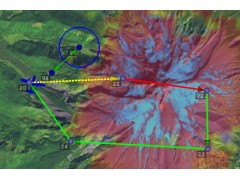
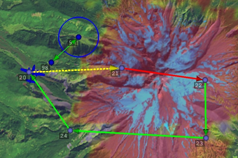
Interactive map displays location and payload sensor footprint on ground. Satellite, streets and maps, or any user supplied map supported
NTSC or PAL recording. Playback includes video, GPS time, plus payload and sensor footprint GPS locations
Moving Map display
Moving target indicator provides easy operator identification of targets overlayed in ViewPoint window
Create video file (AVI output) from recorded files
Supports CCT plug-ins and 3rd party plug-in architecture
Supports IP connection and web serving using MJPEG compression
FEATURE RICH IMAGING SOFTWARE
REAL TIME IMAGE MOSAIC:
The increased information provided by mosaicing displayed in real-time on the ViewPoint interface provides a real advantage to the payload operator, showing path history and a wider situational awareness FOV when zooming in on an object.
OBJECT TRACKING:
The TASE payload autonomously tracks selected objects such as people, cars, trucks or other objects moving in the scene based on image match within a user adjustable target box.
GEO-STAMP:
Allows the operator to designate areas of interest by simply pressing a key or touching the screen. The incident is tagged on a map, a still image is taken and the location is logged in a separate incident folder. The captured still image can be overlaid on Google Earth. This feature is invaluable when a still-image of an object/feature is needed for later reference.
VIDEO ON MAP:
Live video geolocated and terrain warped over moving map. This feature greatly enhances the operators ability to identify the exact location of the object or feature the camera image is looking at.
ELECTRonIC STABILIZATION (E-STAB):
PC-based image stabilization enhances mechanical gyro stabilization.
SCENE STEERING (INCLUDES E-STAB):
PC-based scene tracking centers image and corrects for vehicle airspeed.
VIDEOSIM PLUGIN:
Provides training, demonstration, testing and development support.
ANTENNA PLUGIN:
Provides an integrated solution to either Piccolo Command Center (PCC) or the payload user interface (ViewPoint) for control of a third party positioner.