


Overview
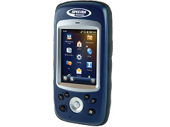
The Spectra Precision MobileMapper 20. with its compact design, provides an easy to use mapping solution for real-time collection of precise data. This unit enables users to record their assets in real-time with meter-level accuracy. Users can further improve the accuracy to sub-meter level through post-processing.
The MobileMapper 20 has a rugged housing and is suitable for outdoor applications. Its capability to connect fieldwork with office work force allows it to improve productivity. The MobileMapper software is a set of utilities with GIS features. This software can run on all MobileMapper receivers, and can be used to collect GIS data, manage asset, as well as create maps.
Features
Rugged, small and lightweight design
Collect real-time GIS data
Support meter-level accuracy
Support sub-meter level accuracy with post- processing
Software includes MobileMapper Field and Office software
Run on Windows Embedded Handheld 6.5 operating system
Technical Specifications
Channels: 20
Signals: GPS L1 and SBAS
Size (H x W x L): 2.5 cm x 16.9 cm x 8.8 cm
Weight: 380/310 g (without/with battery)
Operating temperature: -10 Celsius to +60 Celsius
Communication protocols: USB, Built-in WiFi, Bluetooth, and GSM/GPRS/HSPA
Ordering
The MobileMapper 20 from Spectra Precision is available through Canal Geomatics. If you would like more information about this unit, please fill in the Request Pricing form and send us your inquiries.
Spectra Precision MobileMapper 20