

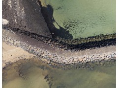
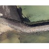
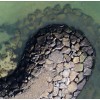


The images below are from a 280 Megapixel orthophoto covering approximately one kilometre of coastline, from a demonstation survey in 2014. The zoomed-in lower image shows the level of detail achieved with 3 centimetres per pixel. It is quite remarkable when one considers that this level of detail exists across the entire surveyed area.
Because the imagery is geo-referenced, coordinates of objects can be displayed, and distances measured. Many software packages allow this. Typically we also provide a 3-dimensional Digital Surface Model and full-colour Point Cloud. These products are also geo-referenced, and we can help you selec software for viewing and measuring the data.