

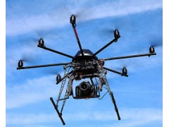
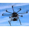


Der 6sGEO - All-In-One solution in the field of surveying and geodesy
Achieving the necessary amount of points with conventional methods of geodesy and object surveying is only possible with enormous efforts of personell expenses and cost. Furthermore there are also risks to personnel and material.
Our 6sGEO takes the relevant data in mid-air high above the ground, which makes it possible to effortlessly survey even hard to reach objects. Our solution guarantees an extremely high ground resolution in the range of just few millimeters per pixel.
Features of the 6sGEO
Flying-time of up to 45 minutes with just one charge (which is equivalent to a distance of around 3 - 4 kilometers)
6sGEO withstands strong winds of up to 6 beaufort
extremely high ground resolution in the range of just millimeters per pixel
robust frame construction with a CFRP jacketing while at the same time ensuring maximum weight efficiency
supports a diversity of camera solutions
Safety features: Redundance, Carefree 2.0, Failsafe, (Dynamic) Position Hold, automatic take-off, landing
MC 32 HoTT ground station adapted to MikroKopter technology with audio-visual integration of all the necessary telemetry information
ground coverage of 100.000m² up to 200.000m² in just one flight
Simple and intuitive handling with high flexibility