

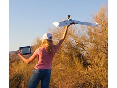


The most easily operated drones.
Take advantage of OperationCenter - a native touchscreen app.
OperationCenter is a professional software for flight planning, aircraft control and post-flight data management, natively running under Windows8.1 Operating system. Use it to «draw» your flight path on any touchscreen Windows8.1 Tablet and wait till the OpsCenter, in a matter of seconds, will generate your mission. Transmit the data to the drone by WI-FI and launch it.
The L-A-series aerial robot will automatically accomplish the mission and come back to you.
No piloting, minimum training needed. Incredible ease of use.
Light. Rugged. Powerful.
And ready for tough missions.
Despite their ultra light weight of 950g (2 lb) only and compact size, L-A series drones are ultra rugged and powerful UAS, flying at speeds of up to 80km/h (45kt) and natively designed for harsh environments: from -25 °C to +60 °C temperatures (-13 °F to 140 °F) and with winds of up to 35 km/h (20kt). From desert to snowy mountains, the L-A series drones are proven to fly in any part of the World.
LA200. Long range. For professional photos.
Perfect for communication purposes.
The LA200 is an automatic drone working with the GoPro camera (oblique or vertical mounts) and any Windows8.1 tablet. To get professional quality aerial still images the user just has to “draw” the flight path in OperationCenter, transmit the data to the drone via WI-FI and launch it. The LA200 flies at a range of up to 3 km.
LA300. Innovation in aerial data acquisition.
Best for mapping and DEM.
The LA300 is an automatic drone working with vertically mounted GoPro Hero3/4 or Canon S110 (day or NIR) cameras, and any Windows8.1 Tablet. To get geo-referenced orthomosaics, DEM or useful NIR images, the user just has to choose the area of interest on the map, after what the OperationCenter will automatically generate the orthomosaic flight path. After transmitting the data to the drone via WI-FI, you just have to launch it and wait till it accomplishes the mission and comes back to you. At the end of the mission the OperationCenter will automatically geo-tag images for you to process them afterwards in the most popular orthomosaics/DEM software for professional maps and 3D surface models.
LA300AG. Fully integrated with MicaSense camera.
Best for precision agriculture.
The LA300AG is an automatic drone working with vertically mounted MicaSense RedEdgde 3 multispectral camera, and any Windows8.1 Tablet. To get useful NIR, B, G or RE images, the user just has to choose the area of interest on the map, after what the OperationCenter will automatically generate the orthomosaic flight path. After transmitting the data to the drone via WI-FI, you just have to launch it and wait till it accomplishes the mission and comes back to you. At the end of the mission the OperationCenter will automatically geo-tag images for you to process them afterwards in the most popular orthomosaics/DEM software for professional maps and NDVI models.