

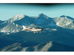


Here at Flight Methods Aviation, Llc. located in Alamosa, Colorado at the Alamosa Regional Bergman Field (ALS) elevation 7,539, we offer a comprehensive program on how to fly safely in the mountains. This program will be tailored to your current level of mountain flying experience, your airplane or ours, how much time you have available and what your training budget is.Our training area is our backyard. We have Mount Blanca, a 14, 345 foot mountain and Crestone Peak at 14,294 feet, 15 minutes flying time from our home field, Alamosa Regional Bergman Field (ALS).Within an hours flight time we can train on many more mountains all with elevations exceeding 14,000 feet. And as a bonus, we can land at Leadville, Colorado (LXV) elevation 9,927 feet, the highest elevation airport in North America and 3rd highest in the World. After landing at Leadville, the airport manager will present you with a Certificate of Achievement documenting your success. Near Leadville is Mount Elbert, the highest point in Colorado at 14,443 feet. Colorado has over 50 mountain peaks over 14,000 feet elevation. We can climb all of them in our airplane!
From Leadville we can cross over the ridge to the West and land in Aspen (ASE) elevation 7,820 feet. Aspen has one runway. Land to the south, takeoff to the north. If the winds are not favorable, best to go some place else. If we do make it in, be sure to text all your friends you just popped into Aspen for a quick bite of lunch.
Departing Aspen to the Southwest, we work some serious ridges and canyons enroute to Gunnison, Colorado (GUC) elevation 7,673, wher the Black Canyon of the Gunnison National Monument is nearby. The Black Canyon is in the top five scenic areas of Colorado. From Gunnison we head Southeast over North Pass (elevation 10,149 feet) back to Alamosa. This program involves approximately 4.5 hours of flight instruction and 1.5 hours of ground instruction including preflight and postflight briefings. The cost for me as your instructor instructor is $495.00 per day. Rental cost for the CE-T206U airplane is $299.00 per hour.
Another mountain training route is from Alamosa, Colorado direct to Telluride, Colorado (TEX) elevation 9,078 feet. Telluride’s airport is unique for several reasons. It is situated on a mesa with cliffs at each end of the only runway. The runway slopes upward in both directions from the middle, in the design of a half moon. So when landing the runway is continually falling away from you. Expect to go-around on your first approach. At the approach end of runway 09 are always down drafts to contend with.
A direct route from Alamosa to Telluride provides a panoramic view of spectacular mountain peaks and valleys. We will fly near Del Norte Peak (elevation 12,400 feet), Pole Creek Mountain (elevation 13,716 feet) and Red Mountain Pass (elevation 11,018 feet).
From Telluride we depart on a Southeast heading for the Animas Air Park (00C) elevation 6,684 feet. This time we pick and choose our route selecing fro a multitude of breathtaking routes. We could encounter Mount Wilson elevation 14,246 feet, Lizard Head Pass elevation 10,222 feet or Hesperus Mountain, elevation 13,232. The Animas Air Park’s only runway sits atop a mesa with an interesting shear vertical dro at the approach end of runway 01. The runway is very narrow and relatively short for our density altitudes. It is only 50 feet wide and 5,010 feet long. . Pinon trees are located on each side of the runway to keep you focused on staying on the runway centerline.
On our way back to Alamosa we encounter Montezuma Peak elevation 13,150 feet, Bennet Mountain elevation 13,203, and Silver Mountain elevation 12,420 feet. Spectacular scenery is available as we are just a few miles South of Wolf Creek Pass elevation 10,850 feet. This program involves about 4.0 hours of flight instruction and 1.5 hours of ground instruction including preflight and postflight briefings. My fee as your instructor is $495.00. Rental cost for the CE-T206U airplane is $299.00 per hour or you are welcome to bring your own airplane.
Here are some are some areas we will discuss during our ground school prior to departure.
1.Density altitude. How to calculate it and its dramatic effect on your engine, propeller and airfoils. A lack of understanding density altitude has got a lot of low land pilots in a lot of trouble while flying in our mountains.
2.We will review the route in detail. Wind speed aloft, wind direction and cloud bases will influence our route selection.
3.You and I will compute weight and balance and takeoff and landing distances
4.We will discuss rules of thumb for determining how much wind is too much, what percent you should be under max gross takeoff weight, how much altitude to have as you approach a ridge or pass and how the winds aloft will affect that number.
5.What to include in your survival pack.
6.We will know all the relevant V-Speeds for the aircraft
7.Why maneuvering speed, Va, is important and how it changes with aircraft gross weight
8.Proper leaning procedures
9.Minimum runway lengths and how to establish a point on the departure runway by which you will automatically abort the takeoff roll if not airborne by that point.
10.Procedures for dealing with severe downdrafts and windshear
11.wher to expect turbulence and how to read the clouds to anticipate the severity of the turbulence
12.Typical weather patterns
13.Determining “Safety Zones” in the mountains
14.Looking at the Big Picture in making the Go-No Go decision
15.Given a particular aircraft make, model and engine and propeller configuration, what kind of mountain flying is safe and what kind to simply avoid.
I have almost 30 years years and over 11,000 hours of flight time in many different ASEL and AMEL makes and models flying around the Rocky Mountains of Colorado. Give me a call or send me an email. Lets get together and have some fun flying in the mountains. I guarantee it will be worth your time. Please call me at 719-580-0225 or contact us via this web site. You can also call our administrative offices and speak with Leslie: 719-587-9593