


Bestseller INTERGEO 2014 and 2015: Instant-Start-Complete-Package for the innovative provider of surveying services at a very attractive introduction price. Orthography up to 1 mm ground resolution and 3D models generated as easy as never before.
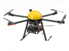
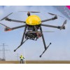
Surveying robot to generate georeferenced photo to build detailed orthophotos, digital elevation models, point cloud generation, volume calculation, 3D models etc.
Incl. camera system and flight planning software
High wind stability up to 10 meter per second
Compact carbon design, foldable
Outstanding innovation "made in Germany": Winner of the Innovation Price 2014
Bestseller INTERGEO 2014 and 2015, best-selling UAV-surveying-system
With the Innovation Price 2014 awarded world first "made in Germany": The MULTIROTOR G4 Surveying-Robot is the first surveying robot in series with the unique MULTIROTOR G4 technology.
Like each MULTIROTOR UAV, the new MULTIROTOR G4 Surveying-Robot is equipped with the MULTIROTOR flight-control, which allows unprecedented measuring and flight precision.
This is enabled by the 32-bit dual-processor board from the MULTIROTOR flight-control with a 10-fold higher computing capacity, state-of-the-art hardware components, a 128 Hz measurement data log and a referenced GPS system.
The set contains everything you need for an immediate take-off.