Delivery Date:Within 3 days after your order is confirmed

The Aibot X6 – An indispensable work tool
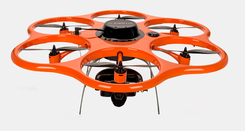
The Aibot X6 is an autonomously flying hexacopter, specifically designed for demanding tasks in surveying, industrial inspection, agriculture and forestry. Equipped with a high level of artificial intelligence, this UAV reaches any target and can independently create high resolution images and videos. An unmatched feature of the Aibot X6 offers the possibility to adapt varying kinds of sensors such as hyper- and multi-spectral sensors, infrared and thermal sensors, and sensors for other industry-specific missions.
A new spin on photogrammetry
Surveying of the future is not fixed and static, but dynamic and flexible. With the data captured by the Aibot X6 commercial UAV and the software solutions of Aibotix and Hexagon, you can generate orthophotos, 3D models and high-density point clouds with great accuracy. The flight planning software Aibotix AiProFlight makes it simple to obtain all the parameters essential for proficient photogrammetry.
Technical data Aibot X6
Length/ Width/ Heigth
1.05 x 1.05 x 0.45 m
Housing CFRP (Carbon Fiber Reinforced Polymer)
Dead Weight
3.4 kg
Take-off weight
4.6 - 6.6 kg
Max. payload1
2.0 kg
Max. speed1
40 km/h (25 mph)
Climb rate1
8 m/s
Fleight height2
Up to 500m (1,640 ft.) over ground, up to 3,000 m (9,843 ft.) above sea level start point
RC range
Up to 1,000 m, fly always in line-of-sight
Flight time1
Up to 20 min
Operating temperature
-20° C to 40° C (-4° F to 104° F)
RTK Yes
GPC-receiver
Yes
Gyroscope Yes
Accelerometer Yes
Barometer Yes
Magnetometer Yes
Ultrasonic sensors
Yes
Standard sensors
Sony ILCE-6000, Sony ILCE-7R, Workswell WIRIS 640, Parrot Sequoia, Headwall Nano-Hyperspec
Control Remore control, automatic waypoint flight
Batteries Lithium-polymer 10,000 mAh
Software Aibotix AiProFlight
Service Service team, hotline, pilot training
Sets + Equipment
On-top camera mounting, digital live video Aibotix Ai DLVP, standard sensors, RTK Aibot HP GNSS 2