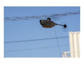
Helinet Aviation has acquired a Phoenix Ranger-LR unit, the company said. The mapping device is on display this week at Helinet’s booth (226) at Airborne Law Enforcement Assn.’s (ALEA) Expo in Reno, Nevada.
The unit uses light detection and ranging (LiDAR) to measure distances. Helinet said the device illuminates targets with a high-precision laser, and interprets the results from the reflected light. It then produces photorealistic 3-D point cloud data, which can provide context, awareness and tactical accuracy, the company said. The device can be used in helicopter or unmanned aircraft system operations.
"Drone-based LiDAR is another emerging tool for law enforcement to gather valuable information and tactically assess large areas," said Jim McGowan, Helinet president and COO.
Helinet said other benefits of aerial LiDAR in law enforcement operations include exposing unmapped trails hidden in remote backwoods, determining width, elevation and length of roads, detecting micro topography hidden by vegetation and gathering ground surface information affected by human activities.
“Aerial LiDAR from a drone or helicopter has proven to be efficient for larger, outdoor scenes as line-of-sight issues can restrict ground LiDAR scans from capturing the entire area,” Helinet said. “Using multiple scans requires stitching, which can negatively impact resolution and accuracy. Airborne LiDAR produces data on everything within its massive swath with pinpoint accuracy, significantly reducing the need for stitching."