


GeoInformation & Image Processing
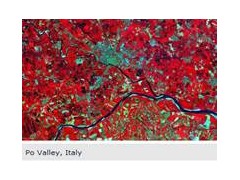
Image processing concerns all systems that rely on visual data such as satelllte images, aerial photography, medical imagery, surveillance videos and all kinds of photographic images.
CS addresses a wide range of domains: command and surveillance centers, automatic object recognition systems, environmental data analysis centers (agriculture, land registry, weather, oceans, rivers), and autonomous vehicles (drones, robots, assisted driving systems).
The CS Image Processing center of excellence operates across the entire production chain, from modeling sensors to systems integration. Our added value lies in our ability to optimize
information in the form of images and video and to extract data that is useful to users. Our engineers have in-depth knowledge of compression standards, the fundamental principles of applied mathematics, algorithms, the physics of measurement, and human perception.
To cope with growing demand in a context wher the performance of sensors is reaching its limit, image processing plays an essential role. Techniques such as merging images (optical + radar for example), integrating exogenous data, segmentation and automatic object recognition, combined with digital terrain model generation and orthorectification, make it possible to augment the capacity of Earth observation systems at reasonable cost.
CS is the main developer of Orfeo ToolBox, an open source library distributed via the CNES. Our experience allows us to supply complete image processing chains. These can be entirely automatic, or they can offer a set of tools that help users produce image-based information.
CS is thus ideally situated to respond to current geospatial intelligence and risk management challenges.
GeoInformation & Image Processing
Moving forward, CS has developed GEOSTORM, a Geo-Information platform designed to store, process and distribute all kinds of geolocated and geolocateable data.
It makes it possible:
To integrate data easily
To geographically enhance information
To significantly increase the power of information by merging data
To publish enhanced data
GEOSTORM architecture uses cutting edge technology to respond to range of requirements: data visualization (ergonomics), intensive data processing (parallelization), ease of use in operational settings, data integration, collaborative work (task sharing, data administration), and so on.
Last but not least, because it has a process organization tool and can interconnect with specific professional tools (in particular Orfeo ToolBox, the open source image processing library also developed by CS), GEOSTORM makes it possible to organize, manage and collate large quantities of data.