


Monitor vegetation
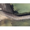
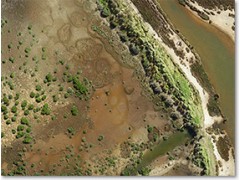
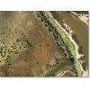
Georeferenced imagery supplied by UAVs is ideal for resource management. Rapid deployment and lower costs allow more frequent flights to monitor changes in vegetation. High resolution allows easy identification of invasive pest species such as Spartina in wetlands. In certain applications, we capture multispectral imagery for identifying weeds. See FAQ.
Post-Burn Assessments
After fuel reduction burns, assessments are greatly assisted by high-resolution, georeferenced imagery provided by our UAVs. After bushfires, when urgent assessments are needed, conventional aerial surveys are sometimes hampered by low-level cloud. Our UAVs avoid this problem because they operate beneath cloud, at altitudes of 400 feet and below.