Industrial Grade Aerial Survey and Data Analysis

Share:         
Price: Negotiable
Min. Order:
Supply Ability:
Delivery Date: Within 3 days after your order is confirmed.
Place Of Origin Britain
Enquiry
Company Profile
  • QuestUAV Ltd
  • 0.00 $ warranty money paid
  • ContactNigel King(Mr.)    
  • Member [Offline now] [Add commercial friends] [Send emails]
  • Email
  • Telephone
  • Mobile phone
  • PortBritain
  • AddressQuest Technology Centre, Coquetdale Enterprise Park, Amble, Northumberland NE65 0PE
 
 
  • Description
  • Quick Details
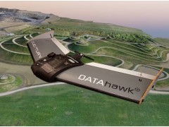
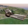
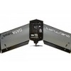
  • Inspired by survey professionals, the DATAhawk is a fully autonomous superior mapping drone from QuestUAV. Easy acquistion of accurate geodata for survey mapping and GIS professionals. Automatically convert your high-res data into geo-referenced 2D orthomosiacs, 3D models and point clouds giving fast and reliable results... every flight.

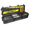
    Rugged, Reliable, Rapidly Deployed

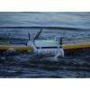
    The QuestUAV DATAhawk design is inspired by survey professionals. A hand-launched, sub 2kg drone that is exceptionally easy to launch with para-recovery for safe operation in confined environments.

    "It's a briliant piece of kit. We were so impressed with the stability of it in high winds and yet still achieving an quality of image similar to a full size QuestUAV" Chris, Tempra.

    0 reviews [ See all reviews ]  Customer Reviews
     
    more»Other
     
    Home | About Us | Contact Us | Intellectual Property | Copyright & Trademark | Legal Disclaimer | Terms of Use | Privacy Policy | Sitemap | Promotion | Ads Service | Web MSG