


Description
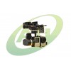
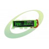
MICASENSE REDEDGE
RedEdge™ simultaneously captures five discrete spectral bands, enabling the creation of tailored indices for customized applications. Global shutter design creates distortion-free images on every platform. A variety of interface options including stand-alone mode, serial, Ethernet, and Wi-Fi, give RedEdge integrators expanded flexibility. RedEdge’s Downwelling Light Sensor (DLS) enables measurement of ambient light conditions during flight for more accurate data in varying light conditions.
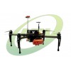
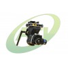
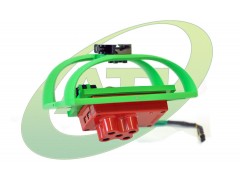
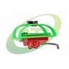
ATI MAPPING GIMBAL
We designed our Mapping Gimbal to be as light and efficient as possible to maximize the flight time of the AgBot™. It is constructed of ultra lightweight materials and aerodynamically optimized. We decided to use servos instead of brushless motors for stabilization because they are lightweight, consume less power and provide more torque. The unique design is tuned perfectly for the RedEdge which means end users will not have to spend time balancing and re-balancing the gimbal to find the correct center of gravity. Our innovative quick release modular payload system allows you to quickly swap out payloads making the AgBot™ a true multi-purpose farm tool. Switch rapidly between multispectral, HD video, thermal and bird deterrent modules or combine any two.
ATLAS
MicaSense ATLAS is a cloud-based data platform for processing, storage, management, presentation, and analytics of multispectral data captured with professional multispectral cameras like RedEdge™ and Sequoia™. This powerful tool takes the tedious work out of generating accurate and meaningful orthomosaics and vegetation index maps, with quantitative information that can be used to properly interpret and understand the condition of your field.
AGPLANNER
The ATI AgPlanner app for Android allows for easy tablet based flight planning with the AgBot™. Quickly create and save repeatable missions to gather plant health trending data over the course of a growing season. AgPlanner works with all modular payloads for the AgBot™ including multispectral, thermal & hi definition sensors.
AgPlanner features an intuitive user interface that also displays flight telemetry data in real-time. Users can quickly find battery health, datalink signal strength, flight time, flight mode, heading & more. A built in pre-flight checklist ensures safe, reliable operation. AgPlanner can also store maps offline which is incredibly valuable when working in remote areas without access to wifi or cellular data networks.