


For many Aeryon customers, GIS imagery and data are an integral part of their day-to-day operations. They rely on this type of information to make mission critical decisions and run their businesses efficiently. Aeryon sUAS have always been designed to collect the right data safely and efficiently. But, collecting data isn’t always enough.
Aeryon sUAS not only collect the right high quality photos and video, but the systems also capture the right metadata (like Geolocation information) on the images to ensure operators can perform the analysis they need to make decision quickly and easily.
Additionally, several of our customers use Esri, the global leader in geographic information system (GIS) technology, software and services, with our sUAS data – an integration that seamlessly works together.
When Esri announced the Drone2Map for ArcGIS beta at the FedGIS User Conference in Washington, DC, earlier this year, the Aeryon team was excited by the news of a dedicated application for processing data from our sUAS within the Esri platform. At the Esri Imagery and Mapping Forum and at the Esri User Conference in San Diego in June, Esri announced that Drone2Map for ArcGIS is in production and available for users.
By combining images from the Aeryon SkyRanger with Drone2Map for ArcGIS, you can create ready-to-use GIS imagery and turn your UAS and the data it collects into a powerful productivity tool. Drone2Map for ArcGIS streamlines the creation of professional imagery products from drone-captured still imagery for visualization and analysis in ArcGIS. It allows you to create orthomosaics, 3D meshes and more, in ArcGIS from your drone-captured still imagery ― in minutes, not days.
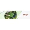
The following is an example of an orthomosaic created with images captured by the SkyRanger. This project (Figures 1. & 2.) took place at a 2 acre (0.8 ha) limestone quarry encircled by steep cliffs up to 40 ft. (12 m) high.