


Features
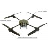
Over three years of R&D have contributed to develop, together with specialists of the inspection of engineered work and aerial photography, a machine dedicated to their profession. The U130 technical assets make it able to provide an exceptional quality for pictures and video, while ensuring and extreme ease of use and setting up.
Autopilot/ Assistance
The Navsense autopilot ensures the drone piloting, from the take-off to the landing, to let the user focused on his mission. The user simply gives command orders via the GCI interface to steer the drone toward the selected observation point. When no command orders are sent, the U130 drone remains automatically on its position thanks to the GPS positioning. Thus, the operator only has to control the shooting.
The automatic navigation mode allows automating the entire mission. The mission planning can be made before or during the flight thanks to the GCS software.
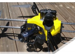
Payload - Video / Picture
The U130 has a turret specially designed to load cameras of professional quality. The turret vertical 180° motorization offers a complete field of view in high-angle and low-angle shot. The payload position in the front of the U130 enables observing a scene without being disturbed by the drone structure. The turret is gyro-stabilized and vibration damped on the roll and pitch axis to improve the shots quality and fluidity.
Easily changed, the payload can be:
A digital camera : 16 Mpx, 4/3" CMOS sensor, removable optical
A digital movie camera : Full HD 1080i, AVCHD codec, 64 Go memory
A thermal camera : 25µm 640480 Micro-bolometer, radiometric, 7.5 to 13µm thermal spectrum, <50mK thermal sensitivity
Various sensors: Gas, Radiation meter, Temperature...
Digital Radiofrequency Transmission
The U130 includes an all digital solution of radiofrequency transmission for both control of the drone and return video. This solution of digital transmission provides a matchless quality of transmission thanks to a proprietary technology of forward error correction (FEC), which ensures the signal continuity in difficult situations.
To guarantee the transmission reliability, two distinct ISM frequency bands are being used.
Novadem has developed its own solution of digital video encoding, which allows the company to guarantee the best performances in the transmission chain: low latency, forward error correction (FEC), proprietary protocol…
Ground Control Software
The Ground Control Software (GCS) which is included in the control interface is intended to simplify and optimize the drone use during its mission. The GCS integrates:
Graphical User Interface (GUI)
- Intuitive and ergonomic to simplify its use
- Configurable according to the missions needs
A full video management :
- Real time visualisation of the video and the flight data
- Piloting assistance: instruments inlaying in the video return
- Pictures and geo-referenced data capture
A cartographic management :
- Real time representation of the drone on a geo-referenced map
- Path and navigation management
Storage of information :
- Video, pictures, flight data and events
- Export of information to other software of cartographic management (GIS)