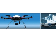


The MK8-3500 Geo
All-In-One solution in the field of surveying and geodesy
Achieving the necessary amount of points with conventional methods of geodesy and object surveying is only possible with enormous efforts of personell expenses and cost. Furthermore there are also risks to personnel and material.
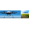
Our 6sGEO takes the relevant data in mid-air high above the ground, which makes it possible to effortlessly survey even hard to reach objects. Our solution guarantees an extremely high ground resolution in the range of just few millimeters per pixel.
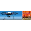
The MK8-3500 Geo Full Package
We put together this full package:
MK8-3500 Geo incl. high power batteries
SLR2 camera mount
specially customized Graupner MC32 HoTT ground station incl. transmitter desk
MK ‚Koptertool‘ software package for waypoint-based flight planning
Separated analogue 5.8Ghz Video RX / TX solution for live image transmission incl. Monitor and battery
Sony Alpha 6000 kamera
Transport box for the drone and the entire equipment
Range Extender for wireless telemetry transfer between PC / tablet and the drone
Graupner Dual Battery Charger
more security through redundancy
extensive, several hours flight lesson within the company
Our Multikopter solutions conforming to the statutory requirements of the Act on radio equipment and telecommunications terminal equipment (R & TTE) were by the Federal Network Agency (BNetzA) regarding successfully checked - with the result.:
The candidate corresponded - with all components (complete avionics, 5.8GHz video transmission system, RC-transmitter / receiver units) - the requirements placed on it!