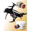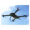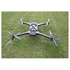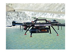
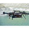


The RIEGL's BathyCopter is a Small UAV-based Surveying System for hydrographic applications ideally suited for generating profiles of inland water bodies.
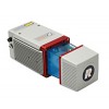
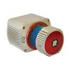
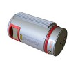
The robust and reliable platform design of RIEGL's remotely piloted RiCOPTER now integrates the new RIEGL BDF-1, a compact and lightweight bathymetric depth finder comprising a tilt compensation, an IMU/GNSS unit with antenna, a control unit and up to two external digital cameras. The BDF-1 can optionally be equipped with a miniVUX-1UAV LiDAR sensor.
The device sends out laser pulses at a rate of 4 kHz. The echo signal of each laser pulse is digitized and recorded for the entire range gate of 50 m. That means, that pre-detection averaging of the waveforms can be performed in post processing, increasing the depth performance.
Subsequently, the waveforms are processed by RIEGL's new and patented hydrographic full waveform processing algorithm, based on exponential decomposition. Finally, data sets with high accuracy, high range resolution, and hydrography-specific attributes are provided, which support point classification.
Main Features
UAV-based surveying system for hydrographic applications
Ideally suited for generating profiles of inland water bodies
Fully integrated solution, comprising RIEGL's new Bathymetric Depth Finder BDF-1 providing up to 1.5 Secchi depth
Essential performance improvement at adverse conditions based on pre-detection averaging
Highly accurate, reliable and informative bathymetric data resulting from RIEGL's proprietary hydrographic waveform processing
Modular setup: The RiCOPTER can be equipped with any combination of BDF-1, floating support, camera(s), and/or miniVUX-1UAV LiDAR sensor
Main Applications
Generation of profiles of inland water bodies (rivers, lakes, channels)
Repeated survey of water reservoirs
Canal surveying
Landscaping
Surveys for planning and hydraulic engineering work