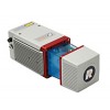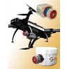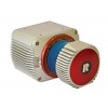


To use the RiCOPTER for acquisition of high-accuracy, high-resolution laser scan and image data, the UAS is equipped with the RIEGL VUX-SYS, comprising the VUX-1UAV LiDAR sensor, a IMU/GNSS unit, a control unit, and up to four high-resolution cameras.
The RIEGL VUX-SYS is a complete miniaturized airborne laser scanning system solution of low weight and compact size for flexible use in UAS/UAV/RPAS, helicopter, gyrocopter and ultra-light aircraft installations. The system consists of the RIEGL VUX-1UAV laser scanner, an IMU/GNSS system, a control unit and up to 4 optional cameras.
The excellent measurement performance of the VUX-1UAV in combination with a precise fiber optic gyroscope and GPS/GLonASS receiver results in survey grade measurement accuracy.
Dedicated interfaces enable full control as well as system status feedback for low bandwidth radio links in UAS/UAV/RPAS systems. Additionally, the control unit contains interfaces for triggering up to four digital cameras. Precise time stamps of the camera's release events are stored in the raw scan data stream enabling subsequent combination of point cloud data and imagery.
Main Features:
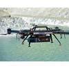
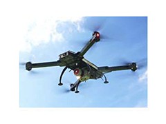
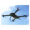
RIEGL RiCOPTER remotely piloted aircraft system equipped with RIEGL VUX-SYS complete miniaturized, lightweight ALS System
RIEGL VUX-1UAV lightweight airborne laser scanner fully integrated
providing 230° FOV
an effective measurement rate up to 350,000 meas./sec
10 mm accuracy
fibre-optic gyroscope and GPS/GLOSNASS receiver integrated
compact control unit with various interfacing options
mounting options for highly flexible aircraft installation
prepared for remote control via low-bandwidth data link
operates up to 2 digital cameras
Main Applications:
Precision Agriculture
Topography in Open-Cast Mining
Terrain and Canyon Mapping
Archaeology and Cultural Heritage documentation
Surveying of Urban Environments
Construction-Site Monitoring
Corridor Mapping:
Power Line
Railway Track
Pipeline Inspection